


In its prime, the Jerusalem Forest covered 4,500 dunams, the JNF goal for it being 6,000 dunams. But sadly, since the early 1970s the forest has dwindled to its present size of a mere 1200 dunams. The neighborhods of Beit Ha-Kerem, Yefeh Nof, Har Nof, Giv’at Sha’ul and Beit Zayit have all expanded at the forest’s expense, and the cemetery slid down from Har Ha-Menuhut to the Roman road and finally to the Jerusalem-Tel Aviv Highway. Enormous quantities of building refuse have been dumped in the forest and an additional 200 dunams have been turned into another cemetery. As if all that were not enough, the Electric Company has planted a network of electricity pylons in the forest, and Yad Vashem has run a new sewage line through it.
The most vulnerable parts of the Jerusalem Forest are the “green fingers” which penetrate into the city itself, adding charm and oxygen to the lucky neighborhoods which border it. These fingers are a link in the ecological corridor which begins with Nahal Revidah and widens into the Sorek river-bed in the city’s western reaches. These green areas are threatened by many plans which are liable to interrupt the ecological corridor at many points and cut off the urban section of the Jerusalem Forest.
Jerusalem residents fighting for the forest’s future have become aware of the severity of the ecological disaster threatening from the west. This awareness has resulted in a broad-based collaboration among the Guardians of the Forest, the committee for the Arazim Valley and the committee for Ein Karem which is promoting a plan to preserve the visual basin of the village. Part of this basin lies within the Jerusalem Forest and it is imperative, from a sustainable planning perspective, that Ein Karem should remain immersed in the Biblical landscape which is a vital component of the village’s conservation. At stake are green areas which constitute an eco-system of the first order. Therefore, when demanding that the Jerusalem Forest be preserved as an urban asset, we must emphasize its role as the urban link in that chain of vital green spaces which, added together, form the green lung west of the city. These spaces are undoubtedly a national asset – the central recreational area of the State of Israel – which is essential in maintaining quality of life for the two big metropolises, Jerusalem and Tel Aviv.
The Jerusalem Forest Masterplan is based on the input from numerous workshops with JNF teams, and with citizens of the neighborhoods surrounding the Jerusalem forest, whose hopes and fears were incorporated into the planning. In addition, the various stages of the plan have been presented to local municipal authorities, the semi governmental greens block, and the management level of the JNF. The work was funded by the JNF.
- Address : Western Slopes Jerusalem
- Region : Mate Yehuda
- Area : 120
- GPS X : 0.000000000000000000
- GPS Y : 0.000000000000000000
- Project start : 1999
- Project end : 2004
- Implementation start : 1999
- Implementation end : ongo
- Context : -
- Website : http://
- Project Status : Implemented in part
- Client : Jerusalem National Fund
- Ownership : Public
- Accessibility : Unrestricted areas
- Project Team : Lawrence Halprin, Judy Green, Ram Eisenberg
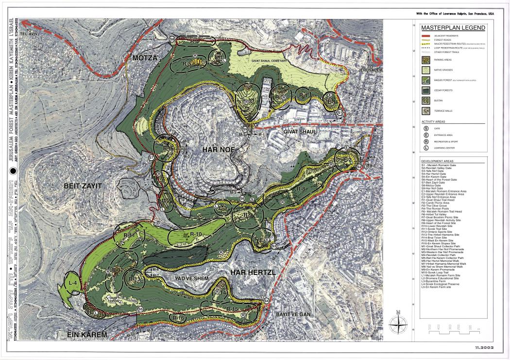
- Brief Description : The Jerusalem Forest master plan defines the development and conservation intentions, and establishes the vision of the forest?s character and style.
- Designer : GEO Architects with the Office of Lawrence Halprin
- Project Name : Original : Jerusalem Forest Masterplan
- Type : Parks
- Image Title : Jerusalem Forest Masterplan
- Image Desc : Jerusalem Forest Masterplan with development areas identified and cut into an aerial photo which shows the surrounding neighborhoods.


